
When it comes to detecting, mapping, and measuring the world around us, three key technologies often come into play — LiDAR, Radar, and Sonar. While each system serves a similar purpose — gathering information about distance, shape, and movement — they operate using very different principles. Understanding these differences is essential when choosing the right tool for your project, especially as industries like surveying, construction, and autonomous vehicles increasingly rely on LiDAR Solutions and related technologies.
Understanding the Basics
At their core, all three systems—LiDAR, Radar, and Sonar—are remote sensing technologies. They send out a signal, wait for it to bounce back from an object, and use the time it takes to return to calculate distance. The main difference lies in the type of energy each uses to detect objects:
– LiDAR (Light Detection and Ranging): Uses laser light to measure distance.
– Radar (Radio Detection and Ranging): Uses radio waves to detect objects and their velocity.
– Sonar (Sound Navigation and Ranging): Uses sound waves, typically underwater, to map surroundings.
LiDAR: Precision Through Light
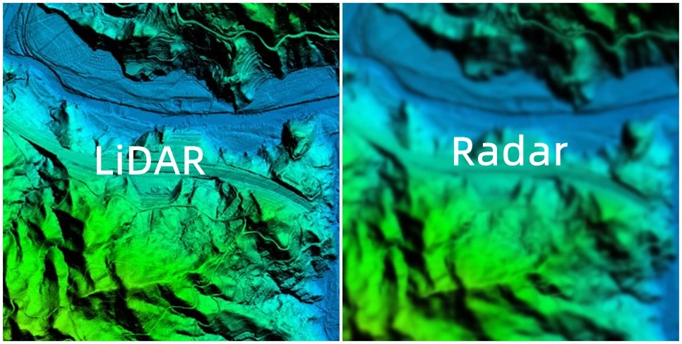
LiDAR works by emitting rapid laser pulses—often millions per second—and measuring the time it takes for each pulse to reflect back from a surface. The result is a highly accurate 3D representation of the environment, known as a point cloud.
This precision makes LiDAR indispensable in applications such as:
– Topographic mapping and surveying
– Autonomous vehicle navigation
– Forestry and environmental monitoring
– Infrastructure and civil engineering
Because light waves are extremely short, LiDAR can detect even the smallest details with centimetre-level accuracy. When combined with GPS and inertial data, it provides a complete spatial understanding of both natural and built environments.
Radar: Reliable in All Weather
Radar, by contrast, uses radio waves, which are much longer than light waves. This gives Radar a major advantage: it can operate effectively in conditions that would hinder optical systems, such as fog, rain, or darkness.
Radar is widely used in:
– Aviation and air traffic control
– Weather monitoring and forecasting
– Maritime navigation
– Military and defence systems
While it’s less detailed than LiDAR, Radar excels at detecting movement, speed, and direction—making it perfect for tracking large objects or vehicles over long distances.
Sonar: Mapping Beneath the Waves
Sonar relies on sound waves to detect and map underwater environments, where light and radio waves are ineffective. There are two main types of sonar:
– Active sonar, which sends out sound pulses and measures their echoes.
– Passive sonar, which listens for sounds emitted by other sources (like marine life or submarines).
Applications of sonar include:
– Seafloor mapping and exploration
– Submarine and ship navigation
– Fisheries and marine biology
Sonar is crucial for understanding oceanic topography and for operations where visibility is limited or non-existent.
Comparing the Three Technologies
| Feature | LiDAR | Radar | Sonar |
| Energy Type | Laser light | Radio waves | Sound waves |
| Medium | Air | Air | Water |
| Accuracy | Very high | Moderate | High (in water) |
| Range | Short to medium | Long | Short to medium |
| Weather Sensitivity | Affected by fog, rain, and dust | Performs well in all weather | Not applicable (used underwater) |
| Common Uses | Mapping, autonomous vehicles, surveying | Aviation, weather, defence | Marine exploration, navigation |
Choosing the Right Technology
The choice between LiDAR, Radar, and Sonar depends on your environment and the level of detail required.
– For above-ground precision mapping: LiDAR offers the best accuracy and resolution, making it the preferred choice for construction, forestry, and autonomous systems.
– For long-distance or poor visibility: Radar remains the most reliable, especially in aviation and meteorology.
– For underwater environments: Sonar is unmatched in its ability to detect and visualise submerged objects and terrain.
In many modern applications, these technologies work together. For instance, autonomous vehicles might use LiDAR for detailed 3D mapping, Radar for long-range detection, and even acoustic sensors for close-proximity awareness.
While LiDAR, Radar, and Sonar all share the same basic principle—sending out signals and measuring their return—they each serve distinct roles in helping us understand our world
LiDAR offers unmatched detail on land, Radar provides reliability across great distances, and Sonar opens a window beneath the waves. As technology advances, we’re seeing growing integration between these systems, enhancing safety, precision, and efficiency across industries. Whether it’s surveying a cityscape, guiding an aircraft, or exploring the ocean floor, the choice of sensing technology shapes how we perceive and interact with our environment.