

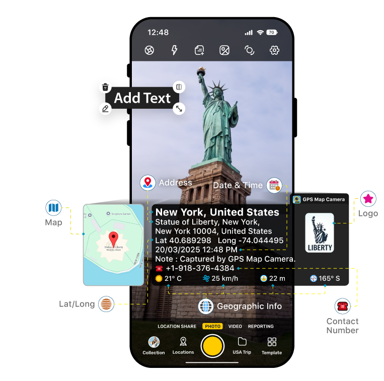
Imagine this — you’re a real estate agent spending your day visiting different homes, construction sites, or new properties. You take hundreds of pictures of rooms, corners, exteriors, and surroundings, but by the time you reach the office, all the photos start to look the same. You can’t remember which one belonged to which location or what time you captured them. Later, when you prepare reports or share details with clients, it turns into confusion. What if every photo could automatically store the property’s exact location, date, and details so you never have to stress about remembering again? That’s where the GPS Map Camera geotagging app becomes your helping app. This app lets you capture GPS photos with automatically embedded details such as location, date, time, coordinates, text, and even notes — right on the image itself.
In simple words, the app does all the remembering for you. Whether you’re inspecting new sites, visiting under-construction buildings, or capturing ready-to-sell homes, each photo becomes a mini record with all the important details put on it. Later, when you look back at the images, you instantly know where and when each one was taken.
How GPS Map Camera Helps Real Estate Professionals in Their Everyday Work:➜
Site Visits Made Easier: Every photo carries the property’s location through geotagging and a timestamp, so you never mix up images from multiple site visits.
➜ Better Client Communication: You can send clients stamped photos that look professional and clearly show where and when each property picture was taken.
➜ Accurate Reporting: The embedded GPS and map details help you create precise reports and maintain property visit records effortlessly.
➜ Faster and Accurate Decisions: Every GPS photo records the property’s exact location, date, and details, allowing you to compare multiple properties efficiently and make reliable decisions without referring to extra notes.
➜ Team Coordination: When working in a team, stamped images make it simple for everyone to identify which site or property the photo belongs to.
➜ Proof of Work: Each photo shows exactly when and where it was taken, serving as evidence that you visited the property or completed inspections. This helps you verify your work to clients, managers, or supervisors, making your reports accurate and trustworthy.
➜ Track Property Updates: With geotagged photos, you can quickly see changes at a site by comparing images from different days, making it easy to monitor construction progress or renovations accurately.
➜ Enhance Client Trust: Stamped and GPS photos make your reports and listings look professional, helping clients feel confident and assured about your work.
This shows how GPS Map Camera makes real estate work easier, more organized, and professional. From accurate site records to better client communication and progress tracking, every feature is designed to save time and support agents in their daily tasks.
Here are Some Key Features that Make GPS Map Camera: a Must-Have App for Real Estate Work.
✔️Add Text (Annotation): This feature lets you include important property details, like project name, plot number, or site phase, directly on your captured GPS photos. When managing multiple sites in a day, it helps ensure every image is properly labeled and easy to identify later.
With geotagging built in, each photo becomes a professional visual record, making reporting, sharing with clients, and tracking property details simpler and more organized.
✔️Add Manual Location: Sometimes you need the exact GPS and map location for a property photo, especially when you’re working across different sites or under-construction projects.
With this feature, you can manually set the precise location to match where the photo was taken. It ensures authenticity and clarity in your records, helping clients to trust.
✔️Folder Saving: Organizing hundreds of property photos can be stressful, but this feature keeps everything sorted automatically. Every photo is saved in a specific folder based on project, client, or site, so you can easily find what you need later. It keeps your gallery neat and every project visually separated.
✔️File Name Customization: With file name customization, you can rename your images based on property names, project codes, or client references.
This small detail saves a lot of time during report preparation or when sharing updates with your team. No more confusion or searching through hundreds of unnamed files.
✔️Weather, Compass, and Wind Info: Environmental details like weather, wind, and direction can play a big role in real estate projects, especially for outdoor sites.
The GPS Map Camera captures all this automatically on a geotagged photo, making every photo a complete scene reference. It helps in tracking on-site conditions and ensures your progress records stay authentic.
✔️Person Name: Add the name of the person who took the photo or managed the site visit to maintain clarity and responsibility. This is especially helpful in team environments where multiple agents or supervisors handle different projects. Each image clearly shows who captured it.
✔️Notes and Hashtags: While capturing photos, you can quickly add short notes, project names, or hashtags that appear right on the image. This makes your GPS photos self-explanatory for clients and colleagues reviewing them later. Whether it’s a quick update or a reminder, your stamped photos always tell the full story without needing extra text or files.
Work Report – Document & Share Property Visits Easily
Create professional reports from your geotagged property photos in just a few taps. This feature makes your site visits organized and presentable without extra effort. Key Highlights: ★ Select Photos: Choose only the images you want in your report. ★ Add Details: Include company logo and company/organization name, Title, Supervisor, Reporter Name, Project Name, and Remarks. ★ Instant Sharing: Export as PDF or share directly with clients or your team. ★ Track Reports: Know exactly where each report has been sent. Why It’s Useful: Turn your photos into a polished, ready-to-share report that saves time, builds client trust, and keeps your property documentation professional.
In a world where real estate depends on accuracy and presentation, the GPS Map Camera app saves time, eliminates confusion, and brings more clarity and authenticity to your work. It’s not just an app—it’s your smart assistant that helps you stay organized, professional, and confident while capturing every property detail effortlessly. So next time you step out for a site visit, make sure your GPS Map Camera is ready — because every great property deserves a photo that speaks for itself. Don’t wait—download GPS Map Camera now and turn every property visit into a fully documented, professional record!